


Tag: hydrographic survey

New charts map seabed and marine ecosystems
(CNS): The newly completed seabed mapping survey of the Cayman Islands by the UK Hydrographic Office (UKHO) will support marine navigation safety and provide an invaluable source of information to support the management, protection and understanding of the local marine environment, according to a release from the Ministry of District Administration and Lands.

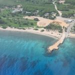
Mapping of Cayman’s seabed underway
(CNS): A team of international geo-data specialists have begun a hydrographic survey to map the local seabed. The project began last week as part of an overseas territories project to reduce risk to the environment, life and vessels. The current hydrographic map data for the Cayman Islands is over 140 years old and this project […]