


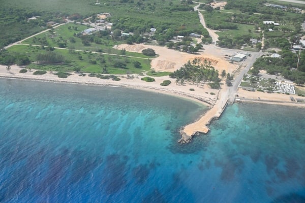
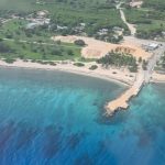
Mapping of Cayman’s seabed underway

(CNS): A team of international geo-data specialists have begun a hydrographic survey to map the local seabed. The project began last week as part of an overseas territories project to reduce risk to the environment, life and vessels. The current hydrographic map data for the Cayman Islands is over 140 years old and this project will provide up-to-date nautical charts for navigational purposes. Although some work was done on sea mapping three years ago in 2018 from boats, this phase involves ariel surveying.
The survey will identify the topography such as hills, valleys, outcroppings and other details that can be hazardous to shipping and the safety of life at sea. The specialists will use a Partenavia P68 aircraft, flying as low as 1000 ft above land and cover 382km2 on Grand Cayman, 70km2 on Cayman Brac and 62km2 on Little Cayman.
The geo-mapping experts from the UK Hydrographic Office are working with the lands ministry.
Director of Lands and SurveyJon Hall explained, “The data collected will be used by UKHO to create new, accurate Admiralty shipping navigation charts for Cayman waters. These will be available for purchase for commercial shipping and private boating purposes from authorized outlets approved by the UKHO. Lands and Survey and the Port Authority will hold copies for operational purposes.”
Hazard Management Cayman Islands (HMCI) will also have access to the data for storm modelling purposes and risk assessment for improved storm surge analysis.
Premier and Minister for Sustainability and Climate Resiliency Wayne Panton said he was pleased that this agency will get access to the information, given “the existential climate related risk of sea-level rise across the Caribbean region”.
He said the sea bed mapping survey contributes to the government’s efforts to “prioritise action to tackle the climate crisis and will be an integral part of the overall Climate Change Risk Assessment previously announced”.
Governor Martyn Roper explained that the project was part of the partnership with the UK and the territories relating to climate change and the environment.
“This £1m cross-OT project looks to reduce risk to the environment, life and vessels in the OTs’ waters, help support compliance with international maritime obligations and support development of blue economies. My thanks to the Ministry of District Administration and Lands for their continued cooperation with the UK Hydrographic Office who are taking this work forward here in the Cayman Islands,” he said.
- Fascinated
- Happy
- Sad
- Angry
- Bored
- Afraid

Category: Local News, Marine Environment, Science & Nature


Hope they have all approvals to photograph the Queen’s bottom!
If you don’t want to wait years for this data if it’s ever bought by the big map companies then just get a garmin unit with contours quickdraw and record your own maps. Couldn’t be easier and you can share them online with everyone.
In or around 1974 the Cayman Islands Dive Club, a branch of the British Sub-Aqua Club surveyed the Georgetown Harbour under the stewardship of the late Gerry Willcocks.( Gerry was later inducted into the International Suba Diving Hall of Fame). A local bank gave the club $6000 for the work. This money together with other funds raised by the club enabled the club to purchase one of the first decompression chambers in the entire Caribbean.
Arising from this the club was awarded the prestigious Heinke Trophy by the British Sub-Aqua Club for having made the greatest contribution to diving during that year. More especially that chamber has saved innumerable lives and enhanced the reputation of the Cayman Islands in the dive industry.
The dive club should be proud of its contributions and in particularly of those of its pioneers.
Thank you Chris for this piece of Cayman history. I have no idea which cretin would give you the thumbs down. As one not born here you do seem to know a lot about Cayman history in general.
17 @ 2:29pm. Chris Johnson has been in Cayman since the late 1960s. He’s seen Cayman just as Sir John Cumber’s vision was materializing. He’s seen Jim & Truman Bodden and almost every politician since destroy Cumber’s vision and sell-out Cayman, to the detriment of Caymanians. In short, Chris has seen Cayman’s very brief rise before it’s present 40-year decline.
Thanks for the history Chris.
Spot on, Chris. I have a few friends and family who were saved the decompression chamber. You are very correct. Good notation of Cayman’s positive historical contributions.
Why did CNS leave out the scary part?
Minister for Lands, Hon. Julianna O’Connor-Connolly concluded, “This seabed mapping project further equips the Government to formulate plans on how this asset can be developed and used for the betterment of all residents of the Cayman Islands.”
The seabed is an asset that can be developed and used? Seriously?
Maybe she was thinking of paving it?
Exploitation, it’s the only reason for it.
will recreational boaters be able to purchase these maps
Read the article.
I’ll bet it’ll be years if ever before Navionics, Garmin, Etc… buy the data and include it in their maps.
This will be a big help for boaters. The available charts are nearly useless.
“ topography such as hills, valleys, outcroppings and other details that can be hazardous to shipping and the safety of life at sea.”. So they are mapping from the air, and apparently land features not marine. I get how land features can be included on navigation charts, but not how that translates into seabed measurement or revising the current charting of the water features. Or how it has anything to do with climate change. Or am I missing something?
You’re missing something. Technology has come a long way since your time.
http://www.bvi.gov.vg/media-centre/low-flying-aircraft-conduct-survey-territory
Try researching Bathymetry LiDAR…and in the future, it’s ok not to have a full understanding about something, but at least ask questions instead of pretending that you’re an expert in a particular area, Capt.
They certainly don’t drop a sounding line down from a plane, if that’s what you’re thinking. It is now done by employing LIDAR.
Must have missed the tender for this one.
Surely our unemployed Caymanians could have done this with some snorkels, masks and fins.
It was previously done in the harbour by the dive club using ropes, scuba gear, weights, boats , compasses etc. It was quite an exercise.
Considering the tender was put out by the UK government, who are paying for it, and encompasses work in multiple jurisdictions, I very much doubt a few unemployed caymanians with snorkels could do it, or a tender as such would be taken seriously!
Fool!