


New charts map seabed and marine ecosystems
(CNS): The newly completed seabed mapping survey of the Cayman Islands by the UK Hydrographic Office (UKHO) will support marine navigation safety and provide an invaluable source of information to support the management, protection and understanding of the local marine environment, according to a release from the Ministry of District Administration and Lands.
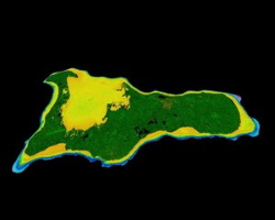
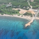
The new charts uncover information about the depth and nature of the seabed and its ecosystems. The UK has also supplied remote monitors to measure local sea-level rise.
The data was officially presented to the Cayman Islands Government in June by UKHO Hydrographic Programme Manager Kerrie Howard, who said it covers both the land and sea for all three islands.
The Department of Lands and Survey is the custodian of the data but the information will also be useful to several other government departments, including the Department of Environment, Hazard Management Cayman Islands, the Cayman Islands Coast Guard, the National Weather Service, the Maritime Authority and the Port Authority.
Premier and Minister for Sustainability and Climate Resiliency Wayne Panton said this mapping covered the shallow seabed from the shoreline out to the drop-off at approximately 130 feet and now provides a clear picture of the bottom structures, including coral, sand and seagrass beds.
“In addition to having such valuable information on the nearshore marine environment, the data will facilitate the creation of more comprehensive storm surge and flooding models, enabling effective mitigation strategies for the impacts of severe weather and climate change,” he said.
“The provision of this technical support is yet another example of the excellent partnership the Cayman Islands Government enjoys with the United Kingdom. We are grateful for the support of the Governor’s Office, the UK Hydrographic Office and the Joint Nature Conservation Committee for their collaboration on this project.”
The survey was undertaken in November last year by international geodata specialists as part of a £1 million cross-overseas territory project funded by the UK Government’s Overseas Territories (OTs) Seabed Mapping Programme. UKHO has also installed four tide gauges that remotely monitor sea-level change.
Lands Minister Juliana O’Connor-Connolly said the information was a “huge leap forward in filling a void in the mapping information” and will be of immense value to the government.
“We recognise that data gathering is an ongoing process to ensure the most up-to-date data is available,” she said, noting that Lands and Survey has aerial photography from the 1950s to the present day but there haven’t been any recent hydrographic surveys that cover the underwater environment of the three islands.
“This survey provides the accuracy needed to ensure world-class operations and service,” she said.
The Cayman Islands was included in the International III Code ‘Flag State’ audit of the UK and Overseas Territories last year which focused on SOLAS (Safety of Life at Sea). Therefore, having current seabed mapping data to the required specification represents a very positive step forward, the release stated.
The latest coastal shipping charts will soon present the latest, most accurate GPS data for waters around the Cayman Islands, helping to make navigation in local waters safer.
As an Overseas Territory, the Cayman Islands Government is given the data but private entities and individuals can buy it from UKHO, which is funded through selling the data it collects to third-parties.
See here for more information about how to access and purchase the data.
- Fascinated
- Happy
- Sad
- Angry
- Bored
- Afraid

Category: Marine Environment, Science & Nature


After all, how many millimeters per year is sea level rising around the Cayman Islands?
The average elevation of Grand Cayman Island is only about 1.7 meters, and the impact of sea level rise on our lives is tremendous, so it is essential to share this information first.
There needs to be an easy way for the nonexpert to order the map. I just tried and could not penetrate the online menus.
Agreed, @CNS it would be great if your article included or inquired as to how to source these maps. Many boaters, including myself and the various watersports operators would be very grateful for the information. One would have thought that CIG (being so proud of it) would have made this information readily available immediately.
CNS: Call Lands and Survey.
We were swindled out of those rights long ago. The fishing banks west of us that are less than 200 miles out belong to Honduras. We can’t fish there legally without permission from Honduras and a Honduran Captain onboard.
The UK are not good with Caribbean maps and naval territorial support. Sailing waters west and south of Cayman are becoming well known warning hot spot for piracy. Cayman should have a UK naval station and home berth for a patrol ship, and maybe a jet that can be scrambled to run cover for Cayman/UK flagged vessels under pursuit. We are the forgotten western Caribbean territory.
Hopefully this will reduce the number of times the Coastguard run their boats up onto the coral.
I need a chip…because i bought one from marine store the other day …..it aint accurate…
Nothing below 130 feet? Our “exclusive economic zone,” or “EEZ” is an area of the ocean, generally extending 200 nautical miles (230 miles) beyond territorial seashore. Have we already been swindled out of those rights?
What ees thees EEZ of which you speak?
Those are national rights belonging to the UK, not regional governments.
Sure, but someone ought to address it.
Absolutely. It should not escape attention that in the articles lauding Caymanian participation in the Alvin research on the mid-Cayman Rise, mineral-rich nodules are just a much a focus as endemic shrimp.
What is your point?