


Tag: Hydrographic Office

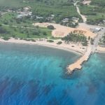
New seabed map to steer vessels to safety
(CNS): Representatives of the UK Hydrographic Office (UKHO) are currently in the Cayman Islands delivering to the Lands and Survey Department the results of a seabed mapping programme that was undertaken last summer. The new map is expected to improve navigation safety in local waters and ensure the territory is fulfilling its international maritime safety obligations […]