


2021 weather review reveals decline in rainfall
(CNS): The average temperature for the Cayman Islands last year was well above normal, and despite an unusually wet August which was soaked by Tropical Storm Grace, rainfall throughout the year was once again below traditional levels. The total rainfall for 2021 was almost 2.3 inches less than the 30-year average. Globally, 2021 was in the top six hottest years on record and there were record-breaking weather events in various places around the world.
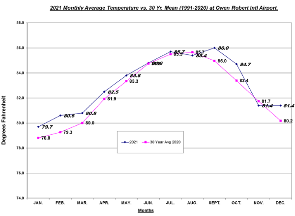
The Cayman Islands also clocked some very high temperatures. The two peaks were on 8 September and 8 October, when the mercury soared to 92.3°F at the highest point for each of those two days. The day with the hottest average temperature (87.4°F) was 7 July.
The coldest point of the year came on 4 February, which had a low point of 66°F, and the day before that, 3 February, was the coolest day overall, with an average temperature of 73.8°F. The average temperature for 2021 was 83.1°F (28.4°C).
The hottest month overall was September, which had an average temperature of 86°F (30°C) and the coolest month overall was January, which had an average temperature of 79.7°F (26.5°C).
As Tropical Grace passed over the Cayman Islands on 18 August it dropped 6.24 inches of rain, which made this year the wettest August on record by far with almost double the average. That day was, unsurprisingly, also the muggiest of the year, with a humidity of 91%.
However, after the downpour brought by Grace, September was not only the hottest month but also the driest on record, with only 1.98 inches of rainfall, less than a quarter of the average.
It rained on 126 days and the total rainfall for the year was 53.74 inches, which is 2.27 inches below the 30-year average. This decline in rain is expected to continue for the first quarter of 2022, as regional weather experts are predicting frequent dry spells in our area.
Over the last five years Cayman has experienced a sustained period of hotter than average annual temperatures and lower than average rainfall, with 2016 still the driest year on record, and a reflection of the impact climate change is having on these islands.


For more information on local weather visit the National Weather Service.
- Fascinated
- Happy
- Sad
- Angry
- Bored
- Afraid

Category: Science & Nature, Weather


We should pay attention to what happened in Phoenix, Arizona. Their rainfall went from rare to almost non-existent while they exploded from a small town into a mega city of pavement, concrete and glass. Their average air temperatures soared well beyond the increase predicted by global warming. Blacktop absorbs heat, heat rises and repels rain. We may already be well on our way to destroying our “island effect rain cloud” that lines up above our island throughout the summer due to moisture rising from our verdant eastern districts, dropping rain on the west end. Ultimately, it seems that all of our environmental, social and criminal woes are due to over-population. If we continue to increase our population (and thus pavement) I expect that we can predict continued decline to all of what makes Cayman such a wonderful place to live… including rainfall.
The airport is in one of the rainier locations. God forbid that NWS have a rain gauge out east where the radar is. Much rain comes from local rain clouds that spring up in the east and drop their rain as they head west.
How do the National Whether or not Service justify this rainfall deficit based solely on one rain gauge at the airport? They have a few more around the island but these only came online late last year.
There have been studies done that show rainfall variability across the island. The deficit this year might be valid for the airport but not Grand Cayman or the islands as a whole. This report in my opinion is just an assumption as -2.3 inches is well within the margin of error if extrapolated to the rest of the island.
Not that there’s been less actual rain, though. In fact, cloud activity has been normal and there has been the usual amount of rain, as virga. However, the precipitation factor has decreased making less rain reach the earth. The precipitation factor is the ratio of cloudiness divided by the percentage of rainfall, per inch/ per square mile, then multiplied by pi subtracted from the inverse percentage of hail or snow experienced. When that number is calculated, it is then averaged over the total area of the location monitored and then amended for the time factor – in a time-lapse manner, using UTC. The final number is the precipitation factor. However, it is not an exact number because the amount of virga which didn’t reach the ground as rain, cannot be estimated. That always skews the real number. In some cases, one can multiply by any factor of two to get a general estimate of the amount of virga. Of course, not forgetting to substract the amount burned-off by UV radiation and blown off by high-level winds.
Sounds about right? Right?
Yawn…
Missing the radar for quite some time
Not for Newlands. We had above average rainfall. Anyone with a cistern can attest to this.
This is what happens when you cut down all of the natural habitat and pave it with concrete. In short, more trees less assholes.
No. Also unable to fix the weather radar for months.
That could possibly be a good thing as Doppler radar has reportedly been used to modify storm tracks such as hurricanes.
19 @ 9:23 am – Yes, doppler has been used to modify the effects of hurricanes. More accurately, “re-purposes”. It was part of a program Donald Trump initiated which included bombing hurricanes with nuclear devices and snorting powdered bleach to fight covid – separate programs but they were co-funded by Congress’ Mean Ways Committee under Trump.
How the doppler effects hurricanes is as follows:
The frequency emitted by the doppler radar changes the molecules of every singly cloud droplet, rain drop, hail stone, snowflake, etc. contained in a given thunder cell. The virga in the thunderhead is turned into naturally-occurring silver iodide due to the doppler ionizing each molecule of moisture. The silver iodide then “seeds” the cloud and converts all the dynamic energy of the vorticular cyclonic action of the hurricane into harmless rain. One small side effect is that everything rained-on will be covered in a sliver dioxide slime. The silver dioxide is a product of the silver iodide oxidizing in the atmosphere as it descends and the temperature increases. This side-effect is presently being addressed by implementing ways to turn the sliver slime into silver filament material to be used in computers and other electronics.
This is a very overlooked development in the fight against hurricane activity and Donald Trump has been nominated for the Nobel Prize in Meteo-radiological Physics for his initiative. As a side recognition, the electronics industry has proposed the highly-coveted Argent Award for the ex-Pres. No one imagined this could be done before Trump came up with it! Astounding!
Sounds about right? Right?
Can’t the National Weather Centre give daily and cumulative totals for rainfall and daily temp ranges like the South Sound privately owned weather station?.
That’s pretty funny 8:41, – maybe start with a trial first and do a running total for how many days the radar has been down 📆
#worldclass